


3-Themenweg


- Flatly
- Possible accommodation
Interactive elevation profile
Create PDF
Tour-Details
Path number: 85
Starting place: 4184 Helfenberg
Destination: 4184 Helfenberg
duration: 4h 0m
length: 14,0 km
Altitude difference (uphill): 408m
Altitude difference (downhill): 409m
Lowest point: 574m
Highest point: 745m
difficulty: medium
condition: medium
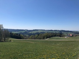
panoramic view: Great panorama
Paths covering:
Asphalt, Hiking trail
powered by TOURDATA
3 themes accompany you on this trail and bring you lots of entertaining, relaxing and interesting facts. 40 panels with funny, serious, witty and witty sayings make for a varied hike. In the first section of the trail, seating designed by artists awaits you, inviting you to rest and enjoy the beautiful views. At the same time, the trail takes you into the past of the village of Helfenberg.
0 km The hike takes you from Ortsplatz Helfenberg (century loom), the traditional craft village (founded as a settlement in 1225), along the main road towards Haslach. After about 300 metres, turn right onto the pavement on the right. Walk uphill to ...
1.5 km Revertera Castle. It is worth taking a look at the beautiful castle garden. Turn left here and head towards the forest, which you cross and reach ...
3.3 km Untereben. From here, walk uphill on the road. After 1.5 km, turn right at the crossroads and immediately take the beautiful ...
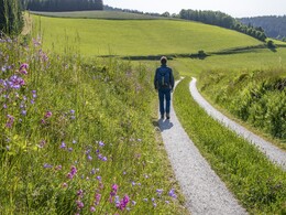
5.0 km meadow path through Himmelreich. This approx. 1.5 km long section is one of the most beautiful on the trail. Now follows an ascending forest path. When you reach the tarmac road, continue downhill to the right. Climbing slightly, you reach the ...
8.0 km Municipal Office of Afiesl. At the forest path uphill you reach the ...
8.5 km forest cross chapel "Maria Rast" after 10 minutes. Take the 5-minute detour to the holy water. According to legend, the Mother of God appeared to a sick castle lady on Piberstein in 1714 and advised her to seek help at this spring. After she was healed, the first wooden cross was erected out of gratitude in 1715, followed by a wooden chapel. The current stone chapel was built in 1836. Follow the Way of the Cross eastwards. After around 450 metres, leave the Way of the Cross and follow the signs to ...
9.8 km to Gasthaus Freller. (If you want to shorten the route by 2 km, continue along the Way of the Cross - not signposted. Before the Steinerne Mühl, we meet the 3 Themen Weg again, which leads down from Piberschlag). From the inn, briefly follow the parallel path to the main road. After about 200 metres, the signposts lead you at a right angle across the meadow towards the forest. Downhill you reach the river ...
10.7 km "Steinerne Mühl" (interesting river bed). Past the power station to the main road. After 100 metres, cross the road and continue along the forest path. Leave the path at the stone formation and continue on the forest path along the stone wall to the tarmac road, which you follow uphill to the left until you reach the houses. Turn right again towards the forest and then steeply downhill to the main road and the beginning of Helfenberg. Continue the hike on the right-hand pavement and take the path over the bridge to Gasthaus Thorwartl. On the right bank of the Steinerne Mühl back to the starting point at the...
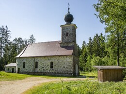
14.0 km Kirche Helfenberg and Gasthof Haudum.
Request our hiking map for EUR 3.00!
With the free outdooractive app, you can hike the trail using navigation.
0 km The hike takes you from Ortsplatz Helfenberg (century loom), the traditional craft village (founded as a settlement in 1225), along the main road towards Haslach. After about 300 metres, turn right onto the pavement on the right. Walk uphill to ...
1.5 km Revertera Castle. It is worth taking a look at the beautiful castle garden. Turn left here and head towards the forest, which you cross and reach ...
3.3 km Untereben. From here, walk uphill on the road. After 1.5 km, turn right at the crossroads and immediately take the beautiful ...
5.0 km meadow path through Himmelreich. This approx. 1.5 km long section is one of the most beautiful on the trail. Now follows an ascending forest path. When you reach the tarmac road, continue downhill to the right. Climbing slightly, you reach the ...
8.0 km Municipal Office of Afiesl. At the forest path uphill you reach the ...
8.5 km forest cross chapel "Maria Rast" after 10 minutes. Take the 5-minute detour to the holy water. According to legend, the Mother of God appeared to a sick castle lady on Piberstein in 1714 and advised her to seek help at this spring. After she was healed, the first wooden cross was erected out of gratitude in 1715, followed by a wooden chapel. The current stone chapel was built in 1836. Follow the Way of the Cross eastwards. After around 450 metres, leave the Way of the Cross and follow the signs to ...
9.8 km to Gasthaus Freller. (If you want to shorten the route by 2 km, continue along the Way of the Cross - not signposted. Before the Steinerne Mühl, we meet the 3 Themen Weg again, which leads down from Piberschlag). From the inn, briefly follow the parallel path to the main road. After about 200 metres, the signposts lead you at a right angle across the meadow towards the forest. Downhill you reach the river ...
10.7 km "Steinerne Mühl" (interesting river bed). Past the power station to the main road. After 100 metres, cross the road and continue along the forest path. Leave the path at the stone formation and continue on the forest path along the stone wall to the tarmac road, which you follow uphill to the left until you reach the houses. Turn right again towards the forest and then steeply downhill to the main road and the beginning of Helfenberg. Continue the hike on the right-hand pavement and take the path over the bridge to Gasthaus Thorwartl. On the right bank of the Steinerne Mühl back to the starting point at the...
14.0 km Kirche Helfenberg and Gasthof Haudum.
Request our hiking map for EUR 3.00!
With the free outdooractive app, you can hike the trail using navigation.
Starting point: Helfenberg town square.
Destination: Helfenberg town square.
further information:
- Flatly
- Possible accommodation
- Board possible
Details - hiking
- themed path
Most economical season
- Spring
- Summer
- Autumn
Please get in touch for more information.
Leonfeldner Straße 15
4184 Helfenberg
Phone +43 5 7890 - 100
Fax machine +43 5 7890 - 115
E-Mail info@boehmerwald.at
Web www.boehmerwald.at/
https://www.boehmerwald.at/
You can also visit us on
Visit us on Facebook Visit us on Instagram Visit our videochannel on YouTube")
")
")

")
Interactive elevation profile
Create PDF
Tour-Details
Path number: 85
Starting place: 4184 Helfenberg
Destination: 4184 Helfenberg
duration: 4h 0m
length: 14,0 km
Altitude difference (uphill): 408m
Altitude difference (downhill): 409m
Lowest point: 574m
Highest point: 745m
difficulty: medium
condition: medium
panoramic view: Great panorama
Paths covering:
Asphalt, Hiking trail
powered by TOURDATA