


Hanriederweg


- Possible accommodation
Interactive elevation profile
Create PDF
Tour-Details
Paths covering:
No circular route!
0 km market square Kollerschlag. Walk along the pavement towards Sarleinsbach. After 200 metres, turn right onto Ameisbergweg, which leads slightly uphill through a settlement to a small wood.
900 m Before the Bildstock at the edge of the forest, the Grenzbachrunde branches off and shortly afterwards the Stoanaweg, which you meet again after approx. 500 m of asphalt road and at the same time the Falkensteinerweg no. 110, which will accompany you to the Ameisbergwarte. Before the...
2.9 km village of Albenödt you separate from the Stoanaweg. Before turning right towards the "Langholz", enjoy the beautiful distant view. The path now turns into a forest road, past the small...
3.5 km "Gatterl" chapel, which was built in 1918. The benches there invite you to take a break. After a 600 m hike in a clearing 50 m away, another rest area offers a beautiful view. Follow the red-white-red colour markings on the trees along the approximately 3 km long, almost flat section of forest road through the Langholz.
6.3 km At the so-called "Bear's Nest" (cross pillar with depiction of the Virgin Mary, 1778), cross the forest road and follow the forest path straight ahead uphill and shortly afterwards come to the tarmac road that leads towards Sarleinsbach. Here you will see the...
6.8 km "Reama Cross" on the right, erected in memory of a brewery driver who died here in an accident in 1890. Now walk uphill in the direction of Mitternschlag. At the tarmac road that leads left to Putzleinsdorf, take the path to the right and now enjoy sweeping views to the east, north and west. Turning left, a steep forest path about 600 metres long now leads you up to the...
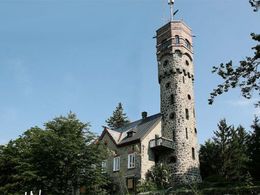
8.2 km Ameisbergwarte (opened in 1903). Norbert Hanrieder was responsible for its construction. A spiral staircase with 135 steps leads to the platform on the tower, which offers an impressive view over the Mühlviertel, the Bohemian Forest, Bavaria, the Innviertel and the Alpine foothills. From a chapel next to the lookout point, the Hanriederweg trail now runs parallel to the Mittellandweg trail no. 150 towards Putzleinsdorf. Continue downhill through the forest until you reach the tarmac road.
9.9 km You walk along this road to Hohenschlag. At the end of the village, leave the road to the left and walk along the old church path, on field, meadow and forest paths, past the cross at the "Hörbiweg".
12.1 km Down to the Steiningergut the path leads somewhat unrecognisably over a short stretch of meadow.
12.6 km Past the farm, the access road leads into Ameisbergstraße, which you continue on to the left. After around 400 metres, turn left at the farm, cross the priority road, Sarleinsbach-Putzleinsdorf, shortly afterwards and walk uphill along the Wulln estate road to the...
13.6 km Turn off at Bründlkapelle (baroque pilgrimage church, built in 1712), which you reach after a few minutes' walk through the forest. The healing waters of the nearby spring were used from around 1650 until the First World War. Here you leave the Mittellandweg. Follow the Stations of the Cross.
15.0 km The last stage leads slightly uphill on the road to the Putzleinsdorf market square.
Request our hiking map for EUR 3.00!
With the free outdooractive app, you can hike the trail using navigation.
- Spring
- Summer
- Autumn
Please get in touch for more information.
Markt 14
4154 Kollerschlag
Phone +43 5 7890 - 100
Fax machine +43 5 7890 - 115
E-Mail info@boehmerwald.at
Web www.boehmerwald.at/
You can also visit us on
Visit us on Facebook Visit us on Instagram Visit our videochannel on YouTube")
")

")
Interactive elevation profile
Create PDF
Tour-Details
Paths covering: