


Weg Sinnenreich


- Flatly
- Possible accommodation
Interactive elevation profile
Create PDF
Tour-Details
Path number: 58
Starting place: 4150 Rohrbach-Berg
Destination: 4150 Rohrbach-Berg
duration: 2h 0m
length: 6,0 km
Altitude difference (uphill): 138m
Altitude difference (downhill): 144m
Lowest point: 521m
Highest point: 618m
difficulty: easy
condition: medium
panoramic view: Great panorama
Paths covering:
Asphalt, Hiking trail
powered by TOURDATA
Here, in the enchanting holiday region of Šumava, your perception will be put to the test at various stations along this trail!
Humming stone - 2 becomes 1 - Walking to (in) the square - When pictures learned to walk - The impossible triangle - Eye pictures (colours without light) - Fluttering echo - How many crows are sitting? - Can tubes hear? - View-Insight-Through-View - Landscape pictures - Finger sensitivity - Irritation in the forest - Alternatives as a challenge - Logo: Optical illusion - Barefoot path - Keeping your balance - Speed
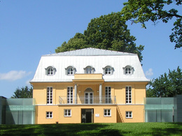
0 km We start in the Park of Villa sinnenreich and go through the large gate onto Harrauer Straße.
The first stations are already waiting for us on the forecourt of the kindergarten. We follow Kindergartenstraße downhill to the left and turn right into Schlosserhügel. Here we keep right until we reach the junction with Grabenstraße. After approx. 60 metres, we turn left onto the Götzendorfer Steig.
1.2 km Passing under the underpass of the bypass road, we come to a biotope with a small rest area that invites us to linger and offers further stations to marvel at. We follow the field path that leads us to ...
1.9 km Lanzerstorfer Holz. Leave the dirt track and turn right into the forest. After about 2 minutes, we cross a small bridge. Shortly after the bridge, we keep right again and continue along the path to the ...
2.5 km junction Polstermühle. Here we leave the forest to the right downhill, past an old house. Turn left at the road. After approx. 10 m at the ...
2.7 km Polstermühle we leave the road again and follow the Fischbach stream to the right in the direction of ...
3.4 km Holzmühle. After a section of meadow, we reach the forest again and follow the edge of the forest uphill for a few steps before the path descends again and joins a wider track on the right. We follow this path until a narrow track branches off to the left. This path leads through an almost enchanted piece of forest to an idyllic bridge, which crosses a small, gently babbling brook. We suddenly hear the noise of the road again, keep left and stay on the wide track that runs slightly uphill parallel to the road on the right. At the bridge over the bypass, we turn left onto the road and follow it through the ...
4.8 km of the village of Harrau to Rohrbach-Berg as far as the Pöschl plumber's. Here we take a sharp left onto Spitalfeld and stay on this road until we reach the car park wall of Villa sinnenreich. Through the large gate we reach the ...
6 km park and our starting point.
Request our hiking map for EUR 3.00!
With the free outdooractive app, you can hike the trail using navigation.
Humming stone - 2 becomes 1 - Walking to (in) the square - When pictures learned to walk - The impossible triangle - Eye pictures (colours without light) - Fluttering echo - How many crows are sitting? - Can tubes hear? - View-Insight-Through-View - Landscape pictures - Finger sensitivity - Irritation in the forest - Alternatives as a challenge - Logo: Optical illusion - Barefoot path - Keeping your balance - Speed
0 km We start in the Park of Villa sinnenreich and go through the large gate onto Harrauer Straße.
The first stations are already waiting for us on the forecourt of the kindergarten. We follow Kindergartenstraße downhill to the left and turn right into Schlosserhügel. Here we keep right until we reach the junction with Grabenstraße. After approx. 60 metres, we turn left onto the Götzendorfer Steig.
1.2 km Passing under the underpass of the bypass road, we come to a biotope with a small rest area that invites us to linger and offers further stations to marvel at. We follow the field path that leads us to ...
1.9 km Lanzerstorfer Holz. Leave the dirt track and turn right into the forest. After about 2 minutes, we cross a small bridge. Shortly after the bridge, we keep right again and continue along the path to the ...
2.5 km junction Polstermühle. Here we leave the forest to the right downhill, past an old house. Turn left at the road. After approx. 10 m at the ...
2.7 km Polstermühle we leave the road again and follow the Fischbach stream to the right in the direction of ...
3.4 km Holzmühle. After a section of meadow, we reach the forest again and follow the edge of the forest uphill for a few steps before the path descends again and joins a wider track on the right. We follow this path until a narrow track branches off to the left. This path leads through an almost enchanted piece of forest to an idyllic bridge, which crosses a small, gently babbling brook. We suddenly hear the noise of the road again, keep left and stay on the wide track that runs slightly uphill parallel to the road on the right. At the bridge over the bypass, we turn left onto the road and follow it through the ...
4.8 km of the village of Harrau to Rohrbach-Berg as far as the Pöschl plumber's. Here we take a sharp left onto Spitalfeld and stay on this road until we reach the car park wall of Villa sinnenreich. Through the large gate we reach the ...
6 km park and our starting point.
Request our hiking map for EUR 3.00!
With the free outdooractive app, you can hike the trail using navigation.
Starting point: Park of the Villa sinnenreich, Rohrbach-Berg.
Destination: Park of the Villa sinnenreich, Rohrbach-Berg.
further information:
- Flatly
- Possible accommodation
- Board possible
Details - hiking
- themed path
Most economical season
- Spring
- Summer
- Autumn
Please get in touch for more information.
Stadtplatz 1
4150 Rohrbach-Berg
Phone +43 5 7890 - 100
Fax machine +43 5 7890 - 115
E-Mail info@boehmerwald.at
Web www.boehmerwald.at
https://www.boehmerwald.at
You can also visit us on
Visit us on Facebook Visit us on Instagram Visit our videochannel on YouTube")
Interactive elevation profile
Create PDF
Tour-Details
Path number: 58
Starting place: 4150 Rohrbach-Berg
Destination: 4150 Rohrbach-Berg
duration: 2h 0m
length: 6,0 km
Altitude difference (uphill): 138m
Altitude difference (downhill): 144m
Lowest point: 521m
Highest point: 618m
difficulty: easy
condition: medium
panoramic view: Great panorama
Paths covering:
Asphalt, Hiking trail
powered by TOURDATA