


Jagaspitzweg


- Flatly
- Possible accommodation
Interactive elevation profile
Create PDF
Tour-Details
Path number: 62
Starting place: 4164 Schwarzenberg am Böhmerwald
Destination: 4164 Schwarzenberg am Böhmerwald
duration: 1h 30m
length: 5,4 km
Altitude difference (uphill): 195m
Altitude difference (downhill): 195m
Lowest point: 685m
Highest point: 865m
difficulty: easy
condition: easy
panoramic view: Some Views
Paths covering:
Asphalt, Hiking trail
powered by TOURDATA
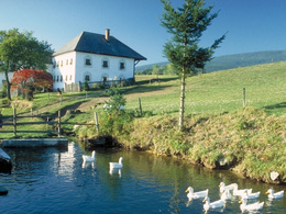
Sunny hiking trail, well suited for families.
0 km The starting point for this beautiful hike is the local centre of Schwarzenberg am Böhmerwald, car park at the Hotel-Restaurant Bergkristall. Following the signs for the Jagaspitzweg, walk downhill past the hotel on the left. At the fork immediately afterwards, keep left, where the path past the house turns into a field and meadow path.
850 m At the start of the Michleggwald, leave the Michleggweg, which has run together until here, and continue to the right parallel to the Witikosteig. Cross the Hartmannsbach stream in the hollow of the valley and shortly afterwards, slightly uphill, you will pass the ...
1.3 km Christian Hof (beautiful farm with a marvellous house façade). Behind the farmstead, follow the tarmac access road to the right and you will reach the ...
1.8 km road that leads from Schwarzenberg to the border crossing to Bavaria. Turn left there and leave the road again after a few metres to join the Zinngießer estate road on the right. Ignore the roads that branch off and continue straight ahead, always looking north towards the Bohemian Forest, until you reach the ,,,
2.9 km Zinngießerhof. The farm is named after a pewterer who appears in documents as early as 1720/21. The three Schwarzenberg glassworks were each also connected to pewter foundry workshops. Although the tinsmiths moved to the glassworks in Sonnenwald when the Schwarzenberg glassworks closed in 1749, the short period of time in which the tinsmiths lived here shaped the name of the house. Both lead into the forest on the right behind the farm. An ascending forest path takes you to a mountain meadow and immediately afterwards to the tarmac road that leads from Schwarzenberg up to Oberschwarzenberg. If you feel thirsty or hungry, turn left, because the ...
3.8 km "Gasthof Dreiländereck" is only a few metres away. If not, keep right and walk downhill on the main road. After approx. 500 metres, don't overlook the turn-off to the left. This is followed by a panoramic section with wonderful views of the idyllic village of Schwarzenberg. When you reach the ...
4.9 km road that leads towards the border, turn into the access road that branches off diagonally opposite and walk past the house and the old linseed oil mill. Following the markings uphill, you will reach your ...
5.4 km starting point.
Request our hiking map for EUR 3.00!
With the free outdooractive app, you can hike the trail using navigation.
Starting point: Schwarzenberg am Böhmerwald town square.
Destination: Schwarzenberg am Böhmerwald town square.
further information:
- Flatly
- Possible accommodation
- Board possible
Most economical season
- Spring
- Summer
- Autumn
Please get in touch for more information.
Hauptstraße 4
4164 Schwarzenberg am Böhmerwald
Phone +43 5 7890 - 100
Fax machine +43 5 7890 - 115
E-Mail info@boehmerwald.at
Web www.boehmerwald.at
https://www.boehmerwald.at
You can also visit us on
Visit us on Facebook Visit us on Instagram Visit our videochannel on YouTube")
")
Interactive elevation profile
Create PDF
Tour-Details
Path number: 62
Starting place: 4164 Schwarzenberg am Böhmerwald
Destination: 4164 Schwarzenberg am Böhmerwald
duration: 1h 30m
length: 5,4 km
Altitude difference (uphill): 195m
Altitude difference (downhill): 195m
Lowest point: 685m
Highest point: 865m
difficulty: easy
condition: easy
panoramic view: Some Views
Paths covering:
Asphalt, Hiking trail
powered by TOURDATA