


Ödenkirchenerweg


- Flatly
- Possible accommodation
Interactive elevation profile
Create PDF
Tour-Details
Path number: 3
Starting place: 4161 Ulrichsberg
Destination: 4161 Ulrichsberg
duration: 4h 0m
length: 13,0 km
Altitude difference (uphill): 364m
Altitude difference (downhill): 372m
Lowest point: 549m
Highest point: 848m
difficulty: medium
condition: medium
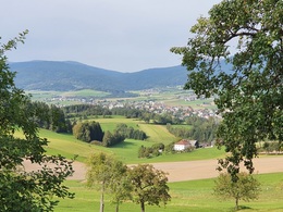
panoramic view: Great panorama
Paths covering:
Asphalt, Hiking trail
powered by TOURDATA
A hike through a rural landscape with narrow strip fields, up to the Zwischenmühl ridge and down into the valley of the Große Mühl.
Marking: yellow aluminium signs, also red-white-red colour markings on trees.
0 km The hike starts at the Ulrichsberg town hall. You pass the savings bank on the right and at the Mitterweg car park you join the Lusweg and follow the yellow signposts with no. 3 down to ...
600 m Naturflussbad at the Große Mühl. Cross the river at the footbridge. A short stretch of meadow now begins, which takes you to a field path after 100 metres. Turn right here and walk along this until you reach the junction to ...
1.7 km Stangl. Continue straight ahead and after 50 metres turn left onto the field path. Initially ascending, then level, you reach ...
2.7 km Kandlschlag. You pass through the small farming village and briefly follow the tarmac road to Fuchslug. After 350 metres, don't miss the turn-off to the left to the edge of the forest. Now walk uphill along the edge of the forest. At the beginning of the meadow that follows, you can enjoy a wonderful view of the interesting strip fields.
These are a special feature of the Mühlviertel cultural landscape and indicate the planned development and division of the sparse land in the Middle Ages. After the short stretch of meadow, a field path follows uphill to ...
4.2 km Ödenkirchen. The history of the Upper Mühlviertel began in this small village. Cistercian monks, commissioned by the Falkenstein family to found the monastery, settled in a place called "Slage" in 1209. This is presumed to be here, and a legend confirms this. After 7 years, however, they left the place again, as they obviously found it too barren and cold. The term "barren church" probably comes from this time. (Literature reference from the hiking book Geh, schau her!). Once you reach the edge of the village on the Aigen-Schlägl - Julbach road, turn right and leave the tarmac road immediately on the left at the barn and walk past the village. On the hill, take a look back and enjoy a wonderful view of the Bohemian Forest and the valley of the Große Mühl (information board). At the next fork in the field path, keep left and head towards the forest, following the red-white-red tree markings to reach the ...
5.7 km Hochhauser (private property, no access). A castle stable, i.e. a small castle or manor house in this area, was mentioned in a document in 1303 - see information board. A steep section of forest now follows. At the bend in the forest road - at the highest point of the hike - continue left along the forest path, which is difficult to see at first but is well marked. At the end of the forest in ...
6.6 km Mitterreit, a magnificent view opens up before you. After a short stretch of tarmac below the farmstead and a left-hand bend, turn left onto the dirt track and you will come to a gate. In front of this gate, a poorly recognisable meadow path leads sharply to the right across the meadow towards the forest.
Now follow the red-white-red tree markings again, which will lead you downhill through the forest. At the end of the forest, above the village of Zaglau, a magnificent view opens up over the Mühltal valley to the Bohemian Forest. You cross the Aigen-Schlägl - Julbach road and walk through the ...
8.9 km village of Zaglau. A little-used tarmac road leads you down to the...
9.8 km Große Mühl. Turning left before the bridge, against the direction of the river, parallel to the Große Mühl hiking trail, you walk past the romantic footpath at ...
11.3 km "Hiatastoa" (large stone in the riverbed) in the direction of Ulrichsberg. Change sides at the Erletbrücke bridge and leave the Große Mühl at the Naturflussbad and walk up to ...
13.0 km Ulrichsberg to your starting point.
Request our hiking map for EUR 3.00!
With the free app outdooractive you can hike the trail by navigation.
Starting point: Ulrichsberg Town Hall.
Destination: Ulrichsberg Town Hall.
further information:
- Flatly
- Possible accommodation
- Board possible
Most economical season
- Spring
- Summer
- Autumn
- Early winter
Please get in touch for more information.
Markt 20
4161 Ulrichsberg
Phone +43 5 7890 - 100
Fax machine +43 5 7890 - 115
E-Mail info@boehmerwald.at
Web www.boehmerwald.at
https://www.boehmerwald.at
You can also visit us on
Visit us on Facebook Visit us on Instagram Visit our videochannel on YouTube")
Interactive elevation profile
Create PDF
Tour-Details
Path number: 3
Starting place: 4161 Ulrichsberg
Destination: 4161 Ulrichsberg
duration: 4h 0m
length: 13,0 km
Altitude difference (uphill): 364m
Altitude difference (downhill): 372m
Lowest point: 549m
Highest point: 848m
difficulty: medium
condition: medium
panoramic view: Great panorama
Paths covering:
Asphalt, Hiking trail
powered by TOURDATA