


Witiko cycle route


- culturally interesting
- Flatly
- Possible accommodation
Interactive elevation profile
Create PDF
Tour-Details
Path number: 811
Starting place: 4184 Helfenberg
Destination: 4184 Helfenberg
duration: 6h 0m
length: 48,0 km
Altitude difference (uphill): 676m
Altitude difference (downhill): 675m
Lowest point: 572m
Highest point: 986m
difficulty: difficult
condition: difficult
panoramic view: Great panorama
Paths covering:
Asphalt
powered by TOURDATA
Cross-border cycling trail through the Bohemian Forest vacation area and the Czech Republic. Travel documents required!
0 km Leave the village of Helfenberg in the direction of Bad Leonfelden and after 1.4 km turn left towards Maria Rast.
3.5 km At the Afiesl/Schönegg municipal office, it is worth making a detour to the Maria Rast forest chapel and the "holy stone", a Celtic bowl stone. Turn left to...
5.1 km to Köckendorf Here you turn right onto the main road and cycle to...
7.8 km to the Czech Republic at the Guglwald border crossing. Cycle straight ahead for approx. 1.5 km to the...
9.3 km junction Pasečná (Reiterschlag). Turn left. After another 6 km, turn right towards...
16.0 km Pasečná. Shortly after the village you have a marvellous view as far as the eastern Alps. Now cycle uphill and after 2.5 km turn left uphill to...
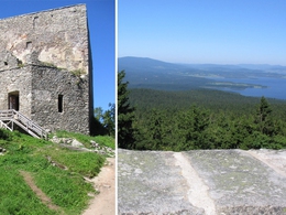
20.3 km Svatý Tomáš. Here it is worth making a detour to the church and continuing uphill to the ruins of Wittinghausen (the highest castle in the Czech Republic), which you can reach on foot. Back at the Hotel Sv. Thomáš (a former forester's lodge), cycle past it on the right. At another junction, leave cycle route 1033 and turn right onto cycle route 1021, which continues downhill to...
27.7 km to Předmostí . Continue along the Vltava reservoir to...
31.4 km Přední Výtoň and turn right at the roundabout, alternating uphill and downhill to the border crossing...
36.4 km Guglwald. After 100 m turn left and after another 100 m turn right. Via Hintermühle you reach...
40.7 km Piberschlag From there, turn right downhill on the Sternwald main road and after approx. 800 m continue left to Mühlholz and uphill to Altenschlag. Cycle right on to the Traberger Landesstraße, turn right and after another 200 m turn right to...
45 km Piberstein Castle. Around the year 1200, the brothers Ruga and Arnold Piber cleared the area, built the Piberstein tower castle and pushed ahead with the colonisation of the primeval forest. After the visit cycle back to the main road and downhill back to the...
48 km starting point Helfenberg.
Request our cycle map here for EUR 3.00!
Use the free outdooractive app to navigate the route.
0 km Leave the village of Helfenberg in the direction of Bad Leonfelden and after 1.4 km turn left towards Maria Rast.
3.5 km At the Afiesl/Schönegg municipal office, it is worth making a detour to the Maria Rast forest chapel and the "holy stone", a Celtic bowl stone. Turn left to...
5.1 km to Köckendorf Here you turn right onto the main road and cycle to...
7.8 km to the Czech Republic at the Guglwald border crossing. Cycle straight ahead for approx. 1.5 km to the...
9.3 km junction Pasečná (Reiterschlag). Turn left. After another 6 km, turn right towards...
16.0 km Pasečná. Shortly after the village you have a marvellous view as far as the eastern Alps. Now cycle uphill and after 2.5 km turn left uphill to...
20.3 km Svatý Tomáš. Here it is worth making a detour to the church and continuing uphill to the ruins of Wittinghausen (the highest castle in the Czech Republic), which you can reach on foot. Back at the Hotel Sv. Thomáš (a former forester's lodge), cycle past it on the right. At another junction, leave cycle route 1033 and turn right onto cycle route 1021, which continues downhill to...
27.7 km to Předmostí . Continue along the Vltava reservoir to...
31.4 km Přední Výtoň and turn right at the roundabout, alternating uphill and downhill to the border crossing...
36.4 km Guglwald. After 100 m turn left and after another 100 m turn right. Via Hintermühle you reach...
40.7 km Piberschlag From there, turn right downhill on the Sternwald main road and after approx. 800 m continue left to Mühlholz and uphill to Altenschlag. Cycle right on to the Traberger Landesstraße, turn right and after another 200 m turn right to...
45 km Piberstein Castle. Around the year 1200, the brothers Ruga and Arnold Piber cleared the area, built the Piberstein tower castle and pushed ahead with the colonisation of the primeval forest. After the visit cycle back to the main road and downhill back to the...
48 km starting point Helfenberg.
Request our cycle map here for EUR 3.00!
Use the free outdooractive app to navigate the route.
Starting point: Helfenberg town square.
Destination: Helfenberg town square.
further information:
- Flatly
- Possible accommodation
- Board possible
")
")
")
")
Most economical season
- Spring
- Summer
- Autumn
Please get in touch for more information.
Leonfeldner Straße 15
4184 Helfenberg
Phone +43 5 7890 - 100
Fax machine +43 5 7890 - 115
E-Mail info@boehmerwald.at
Web www.boehmerwald.at/
https://www.boehmerwald.at/
You can also visit us on
Visit us on Facebook Visit us on Instagram Visit our videochannel on YouTubeInteractive elevation profile
Create PDF
Tour-Details
Path number: 811
Starting place: 4184 Helfenberg
Destination: 4184 Helfenberg
duration: 6h 0m
length: 48,0 km
Altitude difference (uphill): 676m
Altitude difference (downhill): 675m
Lowest point: 572m
Highest point: 986m
difficulty: difficult
condition: difficult
panoramic view: Great panorama
Paths covering:
Asphalt
powered by TOURDATA