


Connecting trail Schwarzenberg - Klaffer


- Possible accommodation
Interactive elevation profile
Create PDF
Tour-Details
Path number: 4
Starting place: 4164 Schwarzenberg am Böhmerwald
Destination: 4164 Schwarzenberg am Böhmerwald
duration: 1h 0m
length: 6,3 km
Altitude difference (uphill): 51m
Altitude difference (downhill): 143m
Lowest point: 601m
Highest point: 740m
difficulty: difficult
condition: medium
panoramic view: Great panorama
Paths covering:
snow
powered by TOURDATA
Trail not in operation
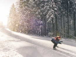
This cross-country skiing track leads to Vorderanger, where you can take the track to Klaffer.Tougher cross-country skiing track.
Note: Grooming of these tracks is dependant on snow and weather conditions. There is no fee and no signage!
For information on the snow conditions please call the tourist office (+43 (0)5 7890 100) or go online.
Get your free cross-country skiing map!
Starting point: Schwarzenberg building yard.
Destination: Schönberg in Klaffer am Hochficht.
further information:
- Possible accommodation
- Board possible
Details - Trail
- Type of Nordic skiing run: Classic + skating
- free
General price information
No trail fee!
Most economical season
- Deep winter
Please get in touch for more information.
Hauptstraße 4
4164 Schwarzenberg am Böhmerwald
Phone +43 7280 255
Fax machine +43 7280 255 - 4
E-Mail info@boehmerwald.at
Web www.schwarzenberg.co.at/
https://www.schwarzenberg.co.at/
You can also visit us on
Visit us on Facebook Visit us on Instagram Visit our videochannel on YouTubeInteractive elevation profile
Create PDF
Tour-Details
Path number: 4
Starting place: 4164 Schwarzenberg am Böhmerwald
Destination: 4164 Schwarzenberg am Böhmerwald
duration: 1h 0m
length: 6,3 km
Altitude difference (uphill): 51m
Altitude difference (downhill): 143m
Lowest point: 601m
Highest point: 740m
difficulty: difficult
condition: medium
panoramic view: Great panorama
Paths covering:
snow
powered by TOURDATA