


Mühlviertler Schnuppertour


- Multi-day tour
- Flatly
- Possible accommodation
Interactive elevation profile
Create PDF
Tour-Details
Path number: R5, R27, R26
Starting place: 4085 Neustift im Mühlkreis
Destination: 4131 Obermühl an der Donau
duration: 10h 0m
length: 118,3 km
Altitude difference (uphill): 2.619m
Altitude difference (downhill): 2.619m
Lowest point: 276m
Highest point: 974m
difficulty: medium
condition: difficult
panoramic view: Great panorama
Paths covering:
Asphalt, Gravel
powered by TOURDATA
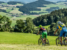
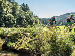
On the 2-day Mühlviertel taster tour, you can immerse yourself in the mysterious and mystical granite landscape north of the Danube.
The cycle path offers sporty pedallers challenging climbs time and again.
The start is in Kramesau/Rannamühl. Follow the R5 on the right, which also begins with the first ascent that takes you to Neustift. From here, the landscape begins to become hilly, as you still have to overcome the mill ridges of the Kleine and Große Mühl. You will be rewarded again and again with wonderful views.
Schwarzenberg forms the centre of the tour. Now follow the signs for the Šumava Cycle Route R27. From here, there are only short, crisp climbs, such as to the Hochficht ski area. Via Schöneben with its observation tower, the Moldaublick (a short detour is necessary for this), Grünwald and Oberhaag, you reach Aigen-Schlägl with the Premonstratensian Schlägl Abbey.
From here, follow the Kleine Mühl Tour R26. The typically hilly route continues to Rohrbach-Berg and further downhill into the valley of the Kleine Mühl to Obermühl an der Donau.
You return to your starting point on the Danube cycle path upstream.
With the free outdooractive app, you can follow the route using navigation.
- Suitable for seniors
- Suitable for single travelers
- Suitable for friends
- Suitable for couples
- Spring
- Summer
- Autumn
Please get in touch for more information.
Hauptstraße 2
4160 Aigen-Schlägl
Phone +43 5 7890 - 100
E-Mail info@muehlviertel.at
Web www.muehlviertel.at
https://www.muehlviertel.at
You can also visit us on
Visit us on Facebook Visit us on Instagram Visit our videochannel on YouTube")
")
")
")

")
")

")
")
Mühlviertel Marken GmbH-Enzenhofer)")
")
Interactive elevation profile
Create PDF
Tour-Details
Path number: R5, R27, R26
Starting place: 4085 Neustift im Mühlkreis
Destination: 4131 Obermühl an der Donau
duration: 10h 0m
length: 118,3 km
Altitude difference (uphill): 2.619m
Altitude difference (downhill): 2.619m
Lowest point: 276m
Highest point: 974m
difficulty: medium
condition: difficult
panoramic view: Great panorama
Paths covering:
Asphalt, Gravel
powered by TOURDATA