


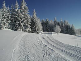
Peilstein small Mühltal trail


Interactive elevation profile
Create PDF
Tour-Details
Path number: 12
Starting place: 4153 Peilstein im Mühlviertel
Destination: 4153 Peilstein im Mühlviertel
duration: 1h 4m
length: 4,3 km
Altitude difference (uphill): 22m
Altitude difference (downhill): 21m
Lowest point: 495m
Highest point: 511m
difficulty: medium
condition: easy
panoramic view: Individual Views
Paths covering:
snow
powered by TOURDATA
Trail not in operation
Peilstein trail network:Small Mühltal valley from the Rinnmühle to the Kobelmühle.
6 km one trail (classic + skating). Please find out about the snow conditions at the tourist information centre +43 057890 100 or online via the current trail report! This is updated daily from Monday to Saturday, except on public holidays, as soon as there is enough snow!
Request our free cross-country ski trail map here!
We would be happy to add you to our mailing list for the daily cross-country ski trail report - just send us a short email: info@boehmerwald.at!
General price information
No trail fee!
Most economical season
- Deep winter
Please get in touch for more information.
Markt 7
4153 Peilstein im Mühlviertel
Phone +43 7287 7203 - 0
Fax machine +43 7287 7203 - 18
E-Mail info@boehmerwald.at
Web www.peilstein.at
http://www.peilstein.at
You can also visit us on
Visit us on Facebook Visit us on Instagram Visit our videochannel on YouTubeInteractive elevation profile
Create PDF
Tour-Details
Path number: 12
Starting place: 4153 Peilstein im Mühlviertel
Destination: 4153 Peilstein im Mühlviertel
duration: 1h 4m
length: 4,3 km
Altitude difference (uphill): 22m
Altitude difference (downhill): 21m
Lowest point: 495m
Highest point: 511m
difficulty: medium
condition: easy
panoramic view: Individual Views
Paths covering:
snow
powered by TOURDATA